Shared:Routing and Visualising Info
Contents |
Routing & Visualising Information
Routing and Visualizing Information is about combining the strengths of two projects mainly based on the routing of people using the NDSM-area. The aim is to interweave the two projects even further and make them benefit from each other. This will result in a meltdown of the key elements of the projects in a physical and virtual way; a routing-system which let people discover NDSM as they never did! Connection. The Lightscape and The Ondina Pavilion will be both physically and virtually connected to each other. The ribbon will constitute a part of the pavilion's structure - the boulevard continues over the pavilions inner space and becomes the roof.- The structure of the pavilion reflects an network as congregation of all different routes over NDSM and will be projected over the main shape of the pavilion. The dimensions of this network are based on ; -the location of the boulevard over the pavilion -direction of sunlight -entrances of pavilion TEXT LIGHTSCAPE PHYSICAL....
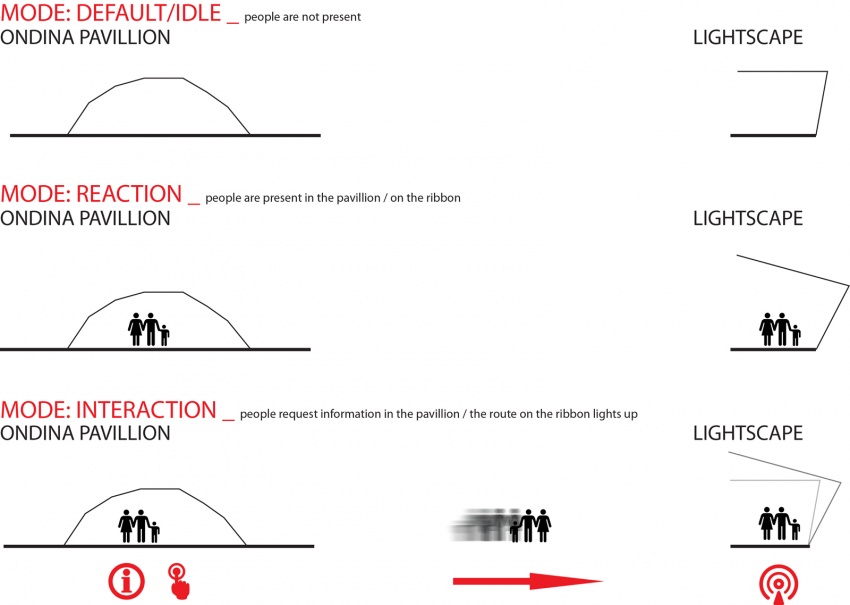
In the virtual way, the two projects together deliver an interactive system, providing the visitors a direction over the NDSM area from the starting point near the ferry platform to other 'snap points'. The Lightscape will be connected to the visual and physical content of the Ondina pavilion, allowing visitors to change the image of the NDSM's lighting ribbon for a short time by demanding their route over NDSM. These connections to other snap points are present within three different layers and modes described below.
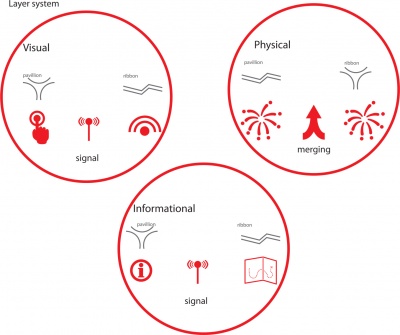
Layer system
The connections between The Lightscape and The Ondina pavilion are based on a network of three different layers, communicating with each other. This network includes an information, a visual and a physical layer. The pavilion provides a signal, which relies on the input from people in the information layer. The output becomes visible in visual layer by showing the route of the person in the lights of The Lightscape. The third layer, the physical layer, is the shape of The Ondina pavilion based on the node of routes and the composition of the elements of The Lightscape.
System objectives
-Usable for everyone (accessible and comprehensible for everyone; no physical nor technological barriers). -Should be working 24/7 (good visibility during day and night). -Network of route with snap points and a central point (Ondina pavilion). -These snap points can be physical or virtual. -Physical pavilions in the 'snap points' are formally based on the Ondina pavilion.
System
The routing system of The Lightscape and The Ondina pavilion is based on a network of different routes, layers, modes interweaved with each other. The output of the system becomes visible after interaction with the main interface in The Ondina pavilion by showing the route of the person in the lights of The Lightscape.
Interface
The interface in The Ondina pavilion forms the input for information and routes to different sites on the NDSM area. The interactive interface is based on the function as network node and is devised into three main blocks (due to the chosen frequency of locations). In these blocks a 1) Person recognizes interactivity functioning person-specific route by the system. 2) Person selects location (word) by standing on it, which causes action in the word (of of interactivity). 3) Sequence action; expand network of words with more options for chosen location (information/route). 4) Person stands again on word (option) within 10seconds to activate the information or the routing system.
REFERENCE (VISUAL COMPLEXITY P.123) DIAGRAMS
Ribbon
TEXT SYTEM RIBBON REFERENCE DIAGRAMS
Modes
TEXT MODES DIAGRAM MODES

